Iron Age people moved a lot. Contrary to the common conception of isolated farmsteads and insular families, Iron Age Britain actually had several dynamic networks of movement.
These could come in the form of trade, war campaigns and migration of peoples. With all this movement, people created routes and trackways that connected different populations and tribal areas, covering vast distances; hundreds of miles.
Some of these Iron Age trackways have been used by generation after generation into the modern period and so can still be followed today!
Why Iron Age Peoples Moved
Warfare
During the Iron Age, before the Roman invasions, Britain was made up of many Celtic tribes and confederacies that engaged in tribal warfare. This meant small-scale conflicts were always arising between neighbouring tribes and diplomatic alliances based on inter-family marriages were always fragile.

As a result, during the summer campaigning seasons, bands of warriors would be constantly on the move for reconnaissance, raiding or full-on assaults against their enemies. In tribal warfare, speed is of the the essence.
Read More: Uncovering the Past with Iron Age Pottery
Therefore, roads and trackways along high ground were the quickest way to traverse the country. Especially since border zones between tribes were often dictated by inaccessible terrain such as swamps or deep forests.
Iron Age Trade
Iron Age trackways weren’t only used for war. There is evidence of extensive trade in between Iron Age cultures, both within Britain and further afield to the continent. Many objects created by the famous European Hallstatt Culture were imported into Britain during the early Iron Age, and later Roman items were traded from networks across the channel.

These foreign objects are not only found in the coastal areas which traded directly with the continent, but are found all cross Britain. Therefore the routes and trackways that crisscrossed Britain formed a trade network linking even the most remote areas of the country to the continent.
It is likely that these beautifully crafted objects changed hands many times, through gift-exchange among elites or direct trade. They may have been viewed with awe and wonder by remote populations at the fringes of the road network.
Migration
The trackways also facilitated the movement of peoples. Throughout Britain’s early history, populations have often migrated, both permanently and seasonally.
During the early Iron Age there was a steady influx of Celtic tribes into Britain from the continent. It’s is likely that they used the trackways during their migrations. Areas with significant seasonal changes such as mountainous or wetland areas often saw seasonal migration of people during the Iron Age.

People would move into the hills during the summer to make use of fresh pasture for their livestock and move back down to shelter during the winter.
Similarly in wetland areas, people would inhabit marshlands during the summer, making use of their fertile soil, rich fishing and bird game. In winter, when these wetlands flooded, people would move to higher ground.
Read More: Menhirs Date From the Neolithic, But What are They?
The county of Somerset was named after the Sumorsæte, or literally “summer-people” who only inhabited the lowland areas during summer. Trackways facilitated this seasonal movement, and indeed were not new to the Iron Age.
People had been building tracks and ‘roads’ since the Neolithic, as evidenced by the Sweet Track – a Neolithic timber causeway across Somerset Levels between two high points. The Sweet Track was likely used for just such seasonal movements by ancient people.
What Were the Trackways like?
These routes often naturally follow the ridges and higher ground across Britain. In a world before maps and compasses travelling on higher ground made journeys easier as the traveller could see far and wide for their next landmark to follow.

The ridges were also drier, with less vegetation, which made travelling along them faster when compared to the lowland valleys. These were often forested, or wet underfoot, or both! Many of the trackways may have simply been a dirt or rocky path along the ridge, kept clear of vegetation by countless travellers making their journeys across the landscape.
Read More: Pingos, an Ice Age Relic Hidden
While the routes followed the high ground, hey were often just below the actual ridge of the landscape. This allowed the traveller to stay a little sheltered from the wind.
Some roads may have been paved or cobbled within Iron Age settlements allowing for easier travel by horse, wagon or chariot. Most Iron Age roads outside of settlements seem to have been un-surfaced, simply beaten down by long use.

However, the find of a properly ‘metalled’ road in Shropshire dating the 1st century BC shows that properly surfaced roads were constructed in Britain even before the first Roman invasions. This road had a deep foundation of clay and wood and was cobbled with stones from the river Severn.
Read More: The Forgotten Roman Roads
Today, many parts of the trackways are lost, buried by the plough, or covered by modern roads and towns. However, parts of these routes still survive, and can be walked along today.
The Harrow Way
The Harrow Way is also known as The Old Way and was used during the Iron Age. Dating between 600-450 BC, it ran from Seaton, Devon to Dover in Kent and is over 200 miles long.

It would have connected most of Southern Britain to the point at which the English Channel is the narrowest; significant for trade with the continent.
Another significant link to trade is that the Harrow Way ends in Devon, where tin and copper were mined from the Bronze Age onwards. This may have been the route that the valuable metals were transported along, traded along the way or destined for Europe.
Read More: A Trip Along Watling Street, The Longest Roman Road in Britain
The name Harrow way may derive from ‘herewag’ meaning ‘military-path’ in Old English, suggesting it was used for war campaigns at least during the Anglo-Saxon period.
The Harrow Way also crosses the landscape and area around Stonehenge and may have been a route of pilgrimage from the Neolithic onwards.

Readers wishing to walk a part of the Harrow Way might choose the Stonehenge area. Here they experience an ancestral landscape with the Neolithic Henge, several Bronze Age barrow cemeteries and the Iron Age hill fort known as Vespasian’s camp.
The Ridgeway and Icknield Way
The Ridgeway and Icknield Way form an ancient Trackway that runs at least 170 miles between Wiltshire and East Anglia. It follows the chalk ridges of the North Wessex Downs, across the Goring Gap and over the Chiltern Hills. The Ridgeway route is a striking example of early travel along ridge lines and downland areas.

In use since the Neolithic, the Ridgeway connected the Dorset coast to the eastern shores of Britain in Norfolk as a reliable trading route that was dry and traversable year round. Numerous ancient landmarks are dotted along the route, including many Iron Age hill-forts.
These hill-forts would have been places of great strategic power during the Iron-Age. Warlords who occupied them could control trade and extend their influence along this ancient trackway.
In modern times, the Ridgeway and Icknield Way have been included into a National Trail. As a result, the general line of the entire ancient route can be followed along modern OS map footpaths from Lyme Regis, Dorset to Holme-next-the-Sea, Norfolk.
Readers wishing to follow in their ancestors footpaths should visit the Neolithic stone henge at Avebury to take in the beauty of the Uffington White Horse. This is a giant chalk-figure of a horse cut into the hillside during the Bronze Age or Early Iron Age. The horse has inspired awe in travellers along the Ridgeway for around 3000 years.
The Fosseway
Fosseway is significant in the history of Iron Age routes as it represents the first Roman road constructed in Britain. Shortly after the Roman invasion of Britain began in 43 AD, the Romans had pushed their border westwards to a line now delineated by the Fosse Way.

This left to the opposing native Britons the territories of the Dumnonii (Devon and Cornwall), Wales and Northern Britain. The term fosse derives from the Latin fossa meaning ‘ditch’.
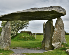
Read More: The Largest Pre-Historic Hillforts you Should Visit
It is thought that the Fosseway probably began as a defensive ditch or a military supply line which supplied the defensive ditch dug by the Romans in order to defend their newly conquered territory. The Fosseway ran 230 miles from the Roman fort of Isca, now known as Exeter, to the Roman settlement of Lindum, now known as Lincoln.

It continued to be used from the Roman period up to modern times. Today, much of the Fosseway forms part of major modern roads. However, there are still stretches of the track which remain as unsurfaced or simple cobbled ‘packsaddle’ roads.
Readers wishing to experience the Fosseway as it might once have looked can still find forgotten stretches of the ancient road.
Read More: Rising from the Ashes: Britain After the Black Death
Ley Lines
First put forward by Alfred Watkins in 1925, ley lines are the name ascribed to ancient trackways taken by humans between places of importance in the landscape.
The idea of this network of surprisingly straight lines was that they formed a network of ancestral memory. They linked places or spiritual, historic or energetic power and are often associated with solar alignment and energy lines.

One argument against this is that ancient places of significance or settlements are so numerous in Britain that any straight line across the land will necessarily cross several of these by chance.
That said, a famous spiritual and mythical location in Britain, Glastonbury Tor is said to lie at the intersection of several ley lines. Walking along its ancient tree-lined trackway, it is easy to imagine the mystical power it might once have had. Readers wishing to visit the old trackway and the Tor might want to visit on a misty morning.
With the Tor rising from the mist, it is reborn as the ancient Isle of Avalon, as it once was known during the Iron Age. This was a time when it rose as an island from the surrounding marshlands, accessed only by a wooden trackway thronged with travellers.