Historic England has successfully identified and marked the locations of these sites, situated to the north of Brighton. Through an extensive analysis of over 9,500 aerial photographs and airborne laser scans,
New research has utilized aerial imagery to map numerous archaeological sites dating from the Neolithic era to the Second World War across the South Downs region.
The outcomes of this study encompass a wide array of archaeological elements, ranging from modest chalk pits to expansive field systems.
Downs from Above is one of 18 projects being delivered as part of the Changing Chalk partnership running for four years until April 2026.
It aims to engage communities as active participants in discovering, interpreting and celebrating the cultural heritage of the Downs.
The partnership is led by the National Trust, supported by a National Lottery Heritage Fund grant and funding from People’s Postcode Lottery.
Historic England’s aerial investigation team analysed more than 9,500 aerial photographs as well as recent airborne laser scans (lidar) – a technique that uses an aircraft-mounted laser to build a 3D digital elevation model of the ground below.
To locate, identify and map marks in the landscape which represent the thousands of years of human activity the Downs have seen. The results cover various archaeological features ranging from small chalk pits to vast field systems.
A supplementary interactive map prompts individuals to contribute data by describing the present state or condition of earthworks, and also provides the option to share personal references to specific sites. The full re
Ancient Burial Sites

Starting from the Neolithic era (4,000 BC to 2,200 BC), burial sites of antiquity were distinguished by the construction of elevated mounds known as barrows.
Scattered across the Downs, these barrows are most prominently positioned along the northern ridge.
Read More: Ancient Trackways: Walking in the Footsteps of Neolithic People
These ancient cemeteries often evolved over extensive time spans and, in certain instances, persisted as significant burial sites even into the early medieval period (AD 410 to 1066).
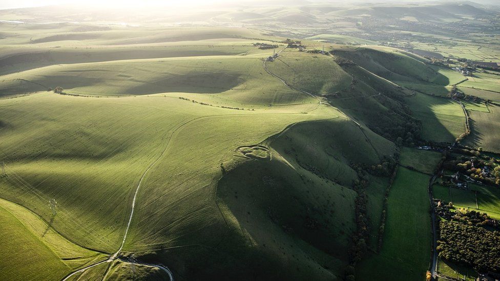
In the region south of Westmeston village, precisely at Western Brow, a cluster of ancient barrows emerges, presenting distinct variations in size and form when viewed from above.
Barrows from the Bronze Age (2,600 BC to 700 BC) are typically larger and tend to cluster together, while those from the early medieval period are generally more compact.
Among the group on the eastern side of Western Brow, smaller mounds enclosed by circular ditches are indicative of the early medieval period, whereas the larger mounds likely trace their origins back to the Bronze Age. This site holds the status of a protected scheduled monument.
Agricultural Landscape

Throughout history, sheep occupied a significant position in agriculture, valued not only for the wool and meat they yielded but also for their crucial role in enriching arable fields through a practice termed sheep and corn farming.
Read More: Menhirs Date From the Neolithic, But What are They?
The tangible traces of sheep husbandry can be observed across the South Downs landscape, manifested in structures like dewponds and livestock enclosures.
Dewponds, designed as artificial watering reservoirs for animals, are distributed across the South Downs, strategically positioned on ridges, hill summits, and within valleys.
Devil’s Dyke

The Devil’s Dyke, a valley shaped like a V, was formed through the combined forces of solifluction and river erosion. The area underwent a period of extreme cold over 14,000 years ago which resulted in the South Downs being covered in snowfields.
The chalk layers beneath were permanently frozen due to permafrost conditions, making it difficult for water to seep through the soil during summer melt.
Read More: Pingos, an Ice Age Relic Hidden
As a result, waterlogged material above the permafrost layer slid down the slope, eroding the top layer of soil and exposing the frozen chalk layers beneath.
Once the Ice Age was over, the snow melted and created rivers in Sussex, which further completed the formation of the Devil’s Dyke valley.
For ages, Devil’s Dyke has enticed visitors with its commanding viewpoint. Originally a site for a defensive hillfort during the Iron Age, it became a popular tourist destination by the Victorian era.
Naval Gun
The mid-19th century saw the expansion of the railway, which made many places including Sussex accessible to the wider public.
The nearby countryside and coast of Brighton served as a place of relaxation and rejuvenation for the middle classes, who recognized the health and recreational benefits of the seaside.
This gave birth to the first holiday destinations, along with various activities and attractions for those with leisure time and disposable income. During its peak, Devil’s Dyke boasted two bandstands, lawns, tea pavilions, a replica 7-ton Naval gun and even a zoo.
Read More: The Forgotten Roman Roads
Dyke Hotel, which was built around 1831, and its adjacent ridge were home to an adventure park, complete with fairground attractions that took up much of the interior of the hillfort.
The site featured a range of fairground rides, including a rollercoaster, and an aerial ropeway where daredevils dangled above the valley in a metal cage suspended from a wire between two metal pylons. Many traces of these attractions are visible on the lidar images.
Then the War Came

In September 1914, a singular day saw the arrival of numerous troops at Shoreham Station, eliciting astonishment among the local populace.
Adverse weather conditions prompted the billeting of many soldiers in local residences overnight, until the eventual establishment of an expansive tented encampment in Buckingham Park and Oxen Fields.
Read More: The Largest Pre-Historic Hillforts you Should Visit
Subsequent days saw the influx of thousands more men, with earnest efforts initiated to construct a hutted camp on Slonk Hill. The remnants of the First World War training camp at Shoreham endured as earthworks until the 1940s, a presence documented in Second World War RAF aerial photographs.
With the eruption of the Second World War, the mounting military activity on the Downs resulted in road closures and the evacuation of farms.
Gradually, the chalk upland transformed into a training and staging area for the D-Day landings in 1944. As the threat of invasion waned, the Downs gradually reopened to the public before the war’s conclusion.
By 1947, amid ongoing rationing, sizeable portions of the traditional grass downland were converted into arable fields to contribute to the nation’s sustenance.
Ancient Routes and tracks

Evidences of numerous tracks, sunken lanes, and pathways crisscross both the Weald and the Downs.
These remnants signify fragments of an intricate web of historic routes spanning various epochs, embodying the enduring trails of human (and livestock) movement across this region.
Read More: Iron Age Trackways That You Can Still Walk Today
A distinguishing characteristic of the northern slope of the South Downs and the corresponding southern aspect of the North Downs are the deeply etched tracks and pathways.
Within this locale, they are referred to as ‘Bostalls,’ a Sussex term denoting incised routes, likely former drove ways. These Bostalls ascend the steep northern escarpment of the South Downs from the Weald, leading onto the open Downs.
Historically employed for the transportation of sheep and other livestock between pastures and markets, as well as routes to the coastal areas, these pathways hold significance.
Industry

Historically Sussex is known for an abundance of raw materials that fed many industries. In the medieval period the Weald became a centre for ironworking and glassmaking and later for brick and tile making.
Chalk extraction and lime burning have also left their mark on the landscape.
Offham, to the north of Lewes, operated a large chalk pit from 1809 to 1890. At its peak of production, Offham Chalk Pit had four lime kilns, which processed the chalk into lime which was transported away by river.
Settlements

The locations of ancient communities and the areas cultivated by our forebears is evident through cropmarks and earthworks scattered throughout the Downs. Soil accumulation along the edges of fields during ploughing results in raised embankments referred to as lynchets.
While lynchets from the later prehistoric or Roman periods, like those found on Balmer Down, can stand up to 3 meters tall, numerous others have been largely flattened over time.
Some of these earth formations might prove challenging to discern on-site, but their identification is facilitated through lidar images.