Roman roads of Britain were marvels of engineering as they were throughout the rest of the empire. Roman roads played a pivotal role in shaping Roman civilisation, acting as a vast network that connected diverse cultures across a vast expanse from Newcastle to North Africa, and from Portugal to Arabia.
The earliest roads specifically built for transit were during the British Iron Age, and the Romans expanded on this during their period of occupation, challenging the long-held perception that the Romans were the first road builders in the UK.
In 1622, French lawyer Bergier made a significant discovery of Roman road remains near Rheims. His fascination with these discoveries led him to delve into classical literature and monuments, which culminated in the first publication on Roman roads.
Bergier’s findings had a profound impact on road construction in 17th and 18th century France, subsequently influencing British roadbuilders like Metcalf, MacAdam, and Telford.
Contents
These builders in the 19th century adopted a scientific approach to developing road construction techniques, many of which remain largely unchanged in modern times. This historical trajectory underlines the importance of understanding Roman road engineering to appreciate the evolution of current UK road construction technology.
Old Tech Reused
The latter half of the 20th century saw the introduction of flexibly bedded pavers as a surfacing material for roads. This development, combined with the rediscovery and study of Roman road building techniques from the 17th to the 19th centuries, highlights the ongoing relevance of understanding Roman road construction methodologies.
Read More: A Trip Along Watling Street, The Longest Roman Road in Britain
This understanding helps us comprehend the origins, motivations, and methods behind Roman road construction and its lasting impact on contemporary road-building practices.

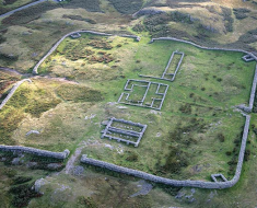
Hadrian’s Wall stands out as Britain’s most extraordinary Roman legacy, stretching 73 miles (117 kilometers) across England from the east coast to the west coast.
Intriguingly, the Roman road tracing its southern edge stands as an unusual instance of a Roman road that isn’t straight.
Read More: Roman Forts Still Litter Our Countryside
Both Hadrian’s Wall and its northern counterpart, the Antonine Wall in Scotland, were strategically placed to take advantage of the natural high terrain. Consequently, the roads connecting their forts and settlements had to adapt to these topographical constraints.
In contrast, the majority of Roman roads elsewhere in the country are known for their notably straight, or at least mostly straight, alignments.
Britain
Roman roads of Britain stand out for a couple of unique features. Firstly, they were part of a cohesive network primarily centered around London. Secondly, their construction was concentrated within a relatively short time frame, from 43 AD to 81 AD, which is curiously similar to the timespan taken to build the current UK motorway network.
This network extended as far north as what is now Perth, with several roads even reaching beyond Hadrian’s Wall.

A distinctive aspect of these roads was the use of an ‘agger’, a raised embankment ranging in height from 300mm to 1.5m. This agger was made using materials dug up from ditches that ran alongside the road. There’s been some speculation about the agger’s purpose.
While some believe it was engineered for drainage, aiding in the preservation of the road surface, others argue it had a defensive role. Given the hostility of the Britons in the initial years after the Roman invasion, the elevated agger would have offered Roman travelers a strategic advantage in visibility and defense.
Read More: What Happened to Britain’s Roman Roads?
It’s important to note that Britain was heavily forested two thousands ago, and these roads were constructed through cleared areas, often with a clearing width of up to 30 meters, despite the roads themselves being less than 10 meters wide. This was likely done for security reasons and to make the roads more navigable.
The famed straightness of Roman roads is also notable. While it might seem surprising, it makes sense considering the shortest distance between two points is a straight line, minimizing construction effort.
Roman surveyors, adept in sea navigation, employed instruments capable of creating long straight lines, making the construction of these straight communication routes a natural choice for them.
Roman roads of Britain, Not So Straight
The Romans were pragmatic in their road construction, often deviating from straight paths to navigate around natural obstacles like valleys and hills. Notably, roads tended to veer off at hilltops, where maintaining a straight line would have been more challenging.

In the more mountainous regions of Northern Britain, roads deviated from straight paths more frequently than in the flatter southern areas. The width of these roads varied, with major routes being about 10 meters wide, other main roads 8 meters, and minor roads typically 5 meters wide. In urban areas, like the streets found in Pompeii, roads were often no wider than 3 meters.
The construction process of a typical British Roman Road
Initially, the designated path was cleared through woodlands. Then, boundary ditches were dug, and deeper ditches along the road edges were excavated to gather material for building the agger.
Read More: Shipyards of Roman Britain, Now Lost?
This material was placed directly on the ground without removing the top layer of soil. At about a meter high, large foundation stones from quarries were laid, followed by a layer of coarse crushed rock or gravel, and then edged with longer stones to contain the gravel.

Typically, two layers of gravel were used, with the top layer being finer and sometimes cemented. The final road surface was made of accurately cut small cobbles, fitting tightly together, employing principles similar to modern paver technology. This was only used in major towns and cities, most roads were paved with gravel.
The precision in stone cutting meant that the stones were often repurposed in later constructions, explaining the scarcity of archaeological remains of these road surfaces.
Roman roads of Britain Three Lanes
While little is known about traffic management on these roads, considering the width of Roman carts (less than 2 meters), it’s plausible that main roads could have supported three lanes. It’s uncertain if there were specific rules for which side to travel on, but it’s likely that travelers used the road’s center unless passing someone.
Read More: Gladiator Battles: The Roman Amphitheatres of Britain
Besides the large ditches used for agger construction, smaller ditches ran parallel to each side of the road, about 1 meter wide and 300mm deep, spaced either 27 or 20 meters apart. These smaller ditches likely marked the road’s boundary, akin to modern highway fences.

In total, four parallel ditches were excavated: two boundary ditches at the clearing’s edges and two larger ditches beside the road for the agger. This arrangement meant that the road, with its central agger, was flanked by large ditches and then an approximately equal width of space on either side.
End of the Roman roads of Britain
After the end of Roman rule in Britain in 410 AD, Roman roads gradually fell out of use, providing us with more insights into their construction materials compared to the Roman roads on the continent. These continental roads often remained in use and were periodically reconstructed.
Read More: Roman Aqueducts and Where to Find Them in the UK
The decline of Roman influence in Britain accelerated around 410 AD, as Saxons and Picts began their incursions. By 450 AD, Roman culture in Britain had largely been replaced, leading to the deterioration of the Roman road network.
Wooden bridges decayed, and roads were frequently obstructed by fallen trees, resulting in the roads fragmenting into isolated segments.
The Saxon economy, centered around local markets, did not necessitate long-distance travel, leading to further neglect of these roads.

Saxons repurposed the aggers as farm boundaries, and during the middle ages, the remaining roads experienced heavy traffic. In the 16th and 17th centuries, when turnpike roads were constructed, materials from the Roman aggers were often reused.
In cases where new roads overlapped with the Roman ones, the agger was sometimes spread out to form the foundation of the new road.
Lasted 350 Years
Due to this neglect and repurposing, only small segments of high-quality Roman roads remain in the UK today. Much of our current knowledge about them comes from recent construction work that has unearthed sections of these ancient roads.
Read More: A Trip Along Watling Street, The Longest Roman Road in Britain
Notably, the Roman road network lasted for about 350 years without significant changes, a rare feat in civil engineering. Understanding their construction and materials is key to appreciating their durability and the evolution of road building.

Interestingly, modern paving systems seem to echo Roman developments. In the early days of the Roman Republic, roads were typically gravel-surfaced, but by the time of Britain’s conquest, major roads were usually paved.
The precision in laying paving stones was remarkable, with one Roman specification requiring joints so narrow that a Roman soldier’s knife couldn’t penetrate them, suggesting joint spacings of less than 3mm. This precision is particularly relevant to modern European highway paver specifications.
Expanding the Road Network
The Romans first arrived in Britain in 55 BC and made a second attempt a year later. On both occasions, led by Julius Caesar, they failed to secure a firm foothold, although Caesar did reach St. Albans in 55 BC before withdrawing to Europe.

At that time, Britain was a land of distinct tribes, mostly speaking a common language, with the major tribes being the Catuvellauni in the Southeast, the Silures in South Wales, the Brigantes in the Vale of York, and the Caledonians in the Grampian Hills and Eastern Scotland.
Read More: How Were Roman Roads Built?
Notably, three significant pre-Roman roads – the Harroway, Icknield Way, and Jurassic Way – originated from Stonehenge. While the Romans often utilized and improved existing roads in other conquered regions, in Britain, they established a completely new road system.
Fourteenth Legion
The successful Roman invasion led by Claudius in 43 AD marked the beginning of road construction, starting in the South East and South Midlands.
After crossing the Thames at London, the Romans captured the Catuvellaunian capital, Colchester, which then became the capital of the new Roman province, Britannia.
The remaining areas of Britain were subdued by legions operating from Colchester, advancing north and west. For instance, the Fourteenth Legion moved along the future route of Watling Street, while the Ninth Legion headed north, facilitating the construction of Ermine Street.

By 50 AD, an extensive road network had developed in Southern England. However, the hilly terrain of the North and Welsh mountains, coupled with local resistance, posed significant challenges.
Conflicts persisted in these regions through the 50s, with Queen Boudica of the Iceni leading a notable rebellion in East Anglia against the Romans in 61 AD.
Read More: Ackling Dyke: A Significant Roman Road?
Initially, Boudica decimated the Ninth Legion but was eventually defeated with reinforcements from the Fourteenth and Twentieth Legions.
This conflict led to the devastation of St. Albans, Colchester, and London. The Ninth Legion later regained its honor in the 70s by defeating the Brigantes and securing York.
Local Labour
Julius Agricola, advancing Roman control in Northern England, utilised the Ninth Legion in the east and the Twentieth in the west, employing local labor for road construction. This included building three cross-country routes: Stainmore Pass, Stanegate, and a road along the River Tweed.
This “ladder” strategy of using main roads with cross-country connections had been successful in Italy and was later applied in North Africa. Stanegate served as an access road for constructing Hadrian’s Wall, which was not a border but a fortification within the Empire.
In terms of road construction, Watling Street was the first major road, stretching from Canterbury to London, following the Romans’ initial landing in East Kent.

With Southampton and Poole as military harbours, early road construction along the south coast linked these ports to Cirencester, Bath, Dorchester, and Exeter, with extensions to the Bristol Channel. By 50 AD, roads reached Gloucester, where a fort was established.
Once Watling Street connected to London, roads branched out in various directions, including to the west, northwest, north, and northeast.
Read More: The Forgotten Roman Roads
Roads were built through important tribal capitals like St. Albans and Colchester, likely to demonstrate Roman dominance. In East Anglia, a comprehensive road network was developed, with Ermine Street as a key route extending to The Wash and beyond.
This network facilitated Roman expansion, with roads like the one from Ermine Street to a port near Caister in Norfolk and another connecting Lincoln to The Wash, a significant Roman naval anchorage.
Waitling Street a Significant Roman Road
Watling Street, an important Roman road, extended northwest from St. Albans through Towcester to Leicester. This road was constructed in segments as Roman control expanded, with branches being added subsequently.
Another notable Roman road, Fosse Way, known for its remarkable straightness, traversed diagonally from Lincoln, through Newark, Leicester, Cirencester, and Bath, reaching all the way to Exmouth.

Initially built in the Midlands in 47 AD as a frontier road, it demarcated the boundary between the agriculturally rich lowlands of Britain and the northern highlands. The configuration of roads intersecting Fosse Way at right angles from the southeast supports this boundary theory.
Read More: Old Sarum a Norman Power Base
As Roman expansion continued into the English highlands, Ryknild Street was built through places like Alcester, Birmingham, Derby, Chesterfield, culminating at the Roman Fort of Templeborough in Rotherham.
Roman Frontier
This road likely marked the temporary northern limit of Roman expansion around 70 AD, with Roman control established east of this line but not yet to the west. By 73 AD, the Roman frontier had moved further north to a line stretching from the Humber through Doncaster and Manchester to Chester.
Julius Agricola’s conquest of North Wales in 78 AD meant that all of Britain south of a line from the Humber to the Mersey was under Roman control by then. The remainder of the Roman conquest and road construction north of this line happened over the next few years.

Dere Street served as the primary road along the east coast, while another northern road paralleled the west coast through Lancashire.
Read More: Anglo-Saxon Churches the Oldest Buildings in the Country
Cross-country northern routes, including the road along Hadrian’s Wall, were developed later, with the wall’s construction between 122 and 126 AD. Dere Street was extended northwards near Edinburgh, linking with roads leading to Strathmore and east coast ports.
The Romans found it more efficient to transport goods to the north by sea, avoiding the hazardous road journey through Britain.
Economic Development
The rapid construction of the Roman road network, despite local tribal hostility, is notable. Conquered peoples were often employed as labourers under Roman supervision, with Roman soldiers executing plans laid out by Roman surveyors.
The establishment of ‘coloniae’, a system originating in Italy, was implemented in Britain, fostering prosperity and stability during the 350 years of Roman occupation. This stability was largely dependent on the Roman roads.
The Roman roads in Britain played a crucial role in the country’s economic development, with settlements quickly emerging along their routes. Roman forts, especially those along Hadrian’s Wall, soon became centers for burgeoning townships as the local population started supplying the Roman military.
This burgeoning trade likely contributed to the cessation of hostilities and the strengthening of Britain’s economy during Roman times.
Roman Roads Today
Several Roman roads, constructed during their conquest of Britain, continue to serve as traffic routes in modern times. Their enduring use is a testament to the Romans’ superior engineering skills and their strategic approach to navigation.

Interestingly, when you use a satellite navigation system today, there’s a high chance you’re tracing a path laid down nearly 2,000 years ago.
Take Fosse Way, for example. In Roman times, it connected Isca Dumnoniorum (now Exeter) with Lindum Colonia (now Lincoln) in a fairly straight trajectory.
Read More: Old Sarum a Norman Power Base
Today, significant portions of this ancient road are still in use, including the A429 in Gloucestershire, the A46 between Lincoln and Leicester, the A37 in Somerset, the A358 near Axminster, the B4455 in Warwickshire, and several routes leading to Exeter.
Originally built to connect south-west England with Lincoln, Fosse Way was a vital link established soon after the Roman invasion in 43 AD. The Roman army used this road as a resting point during their northern and western expansions.
Queen Boudicca’s Iceni Tribe
Another key route from ancient Britain, Watling Street, was built around 47-48 AD. It ran north from London towards Wales, a path now largely followed by the modern A5, extending to Holyhead port. Watling Street also extends southeast as the A2, leading from London to Dover at the English Channel.
Akeman Street, in Roman times, connected Watling Street with Fosse Way, bridging the gap between the Cotswolds and St Albans. Today, the A41 traces much of this ancient route between Bicester and Berkhamsted.
Icknield Street, another Roman road, ran from Bourton on the Water in Gloucestershire to Templeborough in Yorkshire. The A38 now covers much of this route in the Midlands, passing through Derby, Burton upon Trent, and Lichfield.
Read More: Avebury Henge, Largest Megalithic Stone Circle in the World
Pye Road, starting at Venta Icenorum (present-day Caistor St Edmund near Norwich) – once the capital of Queen Boudicca’s Iceni tribe – was a Roman construction. This road, built following Boudicca’s revolt against Roman rule in 60-61 AD, linked Venta Icenorum to Colchester and then to London, the new Roman capital.
Parts of Pye Road now form the A140 through Suffolk and Norfolk, the A118 in north-east London, and sections of Whitechapel Road leading to central London.
Today’s British road users might be surprised to realize that they are frequently relying on the ingenuity of Roman road surveyors. These ancient engineers laid the groundwork for a practical and extensive network of highways across the UK, essentially setting the foundations for the country’s current transportation infrastructure.